|
The APR installation was fitted to
Hudsons VH-AGX, VH-AGS and VH-AGJ at various
times. The equipment consisted of a dish inside the bomb bay directed vertically
downwards through a circular cut-out in the bomb doors. This aperture was covered
externally by a removable fibreglass panel.
To calibrate the equipment on the ground, the bomb bay doors were opened and a
reflector at 45 degrees was placed underneath along the fore/aft axis of the fuselage.
A target was placed at a known distance and the calibration made. In the interests
of sperm count it was advisable not to pass in front of the gear when it was operating!
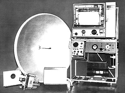
The technician's equipment in the aircraft was set up on the port side of the
main cabin, immediately behind the forward bulkhead. All the electronic gear (valves
in those days), with an oscilloscope was set up on Dexion shelving, and was about
five foot high by four wide. In the center, facing the technician was a continuous
rolling chart on which a pen marked a line showing the profile of the ground directly
underneath the aircraft. The center-line of the chart represented the datum height.
A Vinten 35mm film camera pointed down through the floor on the starboard side
of the bomb bay, next to the dish and had its own access panel for changing film
etc in flight.
The purpose of the APR was to confirm the terrain profiles that had been determined
from previous photographic survey and were usually carried out over the more remote
areas where land survey was impractical. The flight lines were usually drawn on
a series of these photographs that had been taped together to form a long roll.
Navigation was carried out using a standard drift sight that protruded through
the floor just aft of the nose perspex. This had a graticule along the fore/aft
axis and a prism under the instrument that could be tilted to give a view anywhere
from the forward horizon to just forward of the aircraft's position. With the
prism turned fully back, one had a vertical view of the ground beneath and it
was in this position that the drift was ascertained. APR work was carried out
at 10,000ft and once at operating height I would take a drift reading on a heading
appropriate to the datum airstrip. The aircraft had to be flown, as accurately
as possible, down the center line of the airstrip for a datum check to be made.
This could be the base strip or another in the area, the profile of which was
known from ground survey. The equipment would be running on the lead up to the
runway and I would note the heading from the gyro compass repeater in front of
my position in the nose. I would warn the technician of the approach of the threshold
("start datum coming, coming, datum
.. NOW") whereupon the tech would mark the
chart accordingly. At the end of the runway I would then call "end datum
.NOW"
and the chart would be marked again. From the time that the initial datum run
was started, until such time that a similar procedure was carried out at the end
of the sortie, I had to note the time and new bearing of every change in heading.
If the first datum run was not deemed accurate, the pilot executed a procedure
turn and a reciprocal run was made. This was repeated, hopefully not often, if
this was also unacceptable.
If all was well, and a recognizable profile of the strip had been recorded, I
then gave headings to take us to the start of the first survey run. Another drift
check was made before the start of the run and the aircraft was lined up on the
calculated heading near the start point. The technician would be aware that the
start was close and would have the equipment running with the run details marked
on the chart. A view ahead through the drift sight prism would show whether the
aircraft was lined up to pass over the start point and also any feature along
the intended track. If not, I would call heading corrections. All things being
equal, I would then call "start point coming, coming, start point
.. NOW" and
the technician would mark the chart accordingly. The end of the run was treated
the same way. From then on it was a case of navigating the aircraft as close as
possible to the flight lines drawn on the photos or map. I would check the drift
from time to time and ask for heading corrections if needed and also call out
any features on the ground that I thought would make a prominent deflection on
the chart, say an escarpment or creek. The autopilot* on the Hudson was very stable
and, if the conditions were right, long distances could be covered without any
corrections being made. Heading corrections were kept as small as possible and
were usually of one or two degrees, which just needed a touch of the autopilot
knob. The main problem with APR work was turbulence, which could build up very
quickly in the remote areas and many flights were cut short because of it, as
a change in attitude would give false profile readings on the chart. The final
run over the datum airstrip at the end of the sortie had to be as accurate as
the first and in lumpy conditions it was sometimes quite tricky for everyone.
Without it, all would be wasted.
Survey flight times could be anything up to six hours on a good day but the norm
was usually about four. I have many flights of 1 to 2 hours that are listed as
"Attempt Survey" and these would most likely have been cut short because of the
conditions, the equipment usually being pretty reliable.
(* Rick Geary recalls that Hudson VH-AGJ was not fitted with an
autopilot and consequently APR surveys in this aircraft had to be hand-flown!)
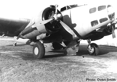
| Hudson
VH-AGS in APR configuration with bomb bay doors
open. [Photo: Owen Smith] |
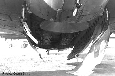
| The
APR installation in the bomb bay of Hudson VH-AGS.
Note the circular cut-out in bomb bay doors and the fibreglass
cover for the aperture. [Photo: Owen Smith] |
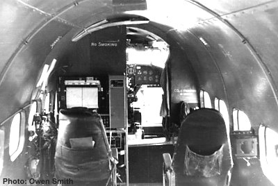
| The cabin
of Hudson VH-AGS showing the APR operator's position
to port. [Photo: Owen Smith] |
For a
further description of APR, please refer to:
Australian Aerial Survey Review
|